

 Send Inquiry
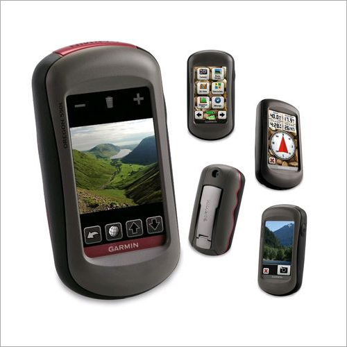
Garmin Etrex 30
Garmin Etrex 30 Specification
- Interface Type
- mini USB, compatible with Garmin custom cable accessories
- Weight
- 141.7 g with batteries
- Dimensions
- 5.4 x 10.3 x 3.3 cm
- GPS Accuracy
- <3 meters (95% typical)
- Battery Backup
- Up to 25 hours (2 AA batteries, not included)
- Display
- 2.2 inch color, 65K colors, TFT, 176 x 220 pixels
About Garmin Etrex 30
Technical Specifications
| Physical & Performance | |
| Unit dimensions, WxHxD | 2.1" x 4.0" x 1.3" (5.4 x 10.3 x 3.3 cm) |
| Display size, WxH | 1.4" x 1.7" (3.5 x 4.4 cm); 2.2" diag (5.6 cm) |
| Display resolution, WxH | 176 x 220 pixels |
| Display type | transflective, 65-K color TFT |
| Weight | 5 oz (141.7 g) with batteries |
| Battery | 2 AA batteries (not included); NiMH or Lithium recommended |
| Battery life | 25 hours |
| Waterproof | yes (IPX7) |
| Floats | no |
| High-sensitivity receiver | yes |
| Interface | USB |
| Maps & Memory | |
| Basemap | yes |
| Preloaded maps | no |
| Ability to add maps | yes |
| Built-in memory | 1.7 GB |
| Accepts data cards | microSD card (not included) |
| Waypoints/favorites/locations | 2000 |
| Routes | 200 |
| Track log | 10,000 points, 200 saved tracks |
| Features & Benefits | |
| Automatic routing (turn by turn routing on roads) | yes (with optional mapping for detailed roads) |
| Electronic compass | yes (tilt-compensated, 3-axis) |
| Touchscreen | no |
| Barometric altimeter | yes |
| Camera | no |
| Geocaching-friendly | yes (paperless) |
| Custom maps compatible | yes |
| Photo navigation (navigate to geotagged photos) | yes |
| Outdoor GPS games | no |
| Hunt/fish calendar | yes |
| Sun and moon information | yes |
| Tide tables | yes |
| Area calculation | yes |
| Custom POIs (ability to add additional points of interest) | yes |
| Unit-to-unit transfer (shares data wirelessly with similar units) | yes |
| Picture viewer | no |
| Garmin Connect compatible (online community where you analyze, categorize and share data) | yes |
What's in the Box:
- eTrex 30
- USB cable
- Manual
Durable and Adventure-Ready Design
Built to endure the outdoors, the eTrex 30 features an IPX7 waterproof rating and rugged construction. It fits comfortably in your hand, weighing only 141.7 grams with batteries, and is perfectly portable for any journey. The devices tough exterior and dependable internal systems ensure performance in rain, mud, or trail dust.
Enhanced Mapping and Navigation
With its high-sensitivity GPS receiver and extensive map compatibility, the eTrex 30 lets you explore confidently. It supports basemaps, TOPO, BlueChart g2, and BirdsEye Satellite Imagery (subscription needed), ensuring detailed navigation. The barometric altimeter delivers accurate elevation data, ideal for hikers and trekkers.
Extended Power and Storage Capabilities
The eTrex 30s long-lasting battery life of up to 25 hours on two AA batteries means you can venture farther without worry. The built-in microSD card slot and generous waypoint, route, and track storage capacity allow you to log every detail of your exploration and expand your mapping resources as needed.
FAQs of Garmin Etrex 30:
Q: How do I add additional maps to my Garmin eTrex 30?
A: You can add compatible maps, such as TOPO, BlueChart g2, or BirdsEye Satellite Imagery, by inserting a microSD card loaded with your purchased maps into the devices expansion slot. Download the maps through Garmins software and follow the prompts to activate them on your eTrex 30.Q: What type of batteries does the eTrex 30 require, and how long do they typically last?
A: The device uses two AA batteries, with NiMH or Lithium recommended for optimal performance. Depending on usage and battery type, you can expect up to 25 hours of operation, supporting long treks and outdoor adventures.Q: Where can I use the Garmin eTrex 30 in India?
A: The eTrex 30 is suitable for use throughout India and can be utilized anywhere GPS signals are accessiblewhether youre hiking, trekking, geocaching, boating, or traveling in remote areas. Its robust design and reliable GPS accuracy make it ideal for varied Indian terrains.Q: What is the process to record and manage waypoints, routes, and tracks on the eTrex 30?
A: To save a waypoint, simply press the mark button at your current location. Plan routes by selecting stored waypoints, and track your journey with the automatic track log feature, which records up to 10,000 points and 200 saved tracks. Manage these via the device interface or export them through mini USB to your computer.Q: How accurate is the GPS on the eTrex 30, and what technology does it use?
A: The Garmin eTrex 30 offers position accuracy within 3 meters (95% typical) thanks to its high-sensitivity GPS receiver, ensuring dependable navigation whether youre under dense forest canopies or in mountainous regions.Q: What are the benefits of the barometric altimeter included in this device?
A: The integrated barometric altimeter provides precise altitude readings by measuring atmospheric pressure, enhancing navigation during elevation changes and assisting in weather trend forecasting while in the field.
Tell us about your requirement

Price:
Quantity
Select Unit
- 50
- 100
- 200
- 250
- 500
- 1000+
Additional detail
Mobile number
Email

More Products in Garmin Gps Device Category
Garmin Oregon 550t GPS
Price 700 INR / Unit
Minimum Order Quantity : 100 Units
Type : Other, Handheld GPS Navigator
Weight : Approx. 6.8 oz (192.7 g) with batteries
Display : Other, 3axis, 65K color, 240 x 400 pixels, sunlightreadable touch screen
Dimensions : 2.4 x 4.5 x 1.4 (6.1 x 11.4 x 3.6 cm)

GPS Radio Collars
Type : Other, Wireless
Weight : 380 g
Display : Digital
Dimensions : 28 x 15 x 7 cm
Garmin 72H GPS Device
Price 5000 INR / Piece
Minimum Order Quantity : 100 Pieces
Type : GPS Navigator
Weight : 10 Kilograms (kg)
Display : Analog
Dimensions : 1 Meter (m)
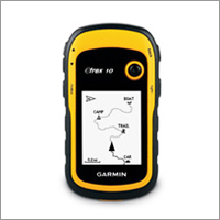
Garmin Etrex 10
Price 14000 INR / Piece
Minimum Order Quantity : 1 Piece
Type : GPS Navigator
Weight : 10 Kilograms (kg)
Display : Analog
Contact Details
- FLAT NO 306, DOOR NO 3-83/1/PC/306, Panchsheel Complex, NIZAMPET.Hyderabad - 500090, Telangana, India
- Phone : 08045476222
GLOBAL TELE COMMUNICATIONS
GST : 36AHTPR9067J1ZA
- Mr Ganesh Chandu R. (Managing Director)
- Mobile : 08045476222
- Send Inquiry
- Mobile :+919866661290


GLOBAL TELE COMMUNICATIONS
All Rights Reserved.(Terms of Use)
Developed and Managed by Infocom Network Private Limited.
Developed and Managed by Infocom Network Private Limited.
