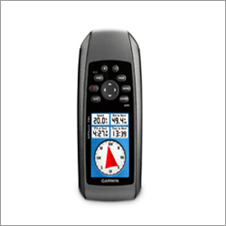
Garmin Gpsmap 78S
Garmin Gpsmap 78S Specification
- Interface Type
- USB, NMEA 0183
- Weight
- 218.3 g (7.7 oz) with batteries
- Dimensions
- 6.6 x 15.2 x 3.0 cm (2.6 x 6.0 x 1.2 inches)
- GPS Accuracy
- <10 meters (RMS)
- Battery Backup
- Up to 20 hours with 2 AA batteries
- Frequency
- L1 (1575.42 MHz) for GPS
About Garmin Gpsmap 78S
Technical Specification
| Physical & Performance | |
| Unit dimensions, WxHxD | 2.6" x 6.0" x 1.2" (6.6 x 15.2 x 3.0 cm) |
| Display size, WxH | 1.43" x 2.15" (3.6 x 5.5 cm); 2.6" diag (6.6 cm) |
| Display resolution, WxH | 160 x 240 pixels |
| Display type | transflective, 65-K color TFT |
| Weight | 7.7 oz (218.3 g) with batteries |
| Battery | 2 AA batteries (not included); NiMH or Lithium recommended |
| Battery life | 20 hours |
| Waterproof | yes (IPX7) |
| Floats | yes |
| High-sensitivity receiver | yes |
| Interface | high-speed USB and NMEA 0183 compatible |
| Maps & Memory | |
| Basemap | yes |
| Preloaded maps | no |
| Ability to add maps | yes |
| Built-in memory | 1.7 GB |
| Accepts data cards | microSD card (not included) |
| Waypoints/favorites/locations | 2000 |
| Routes | 200 |
| Track log | 10,000 points, 200 saved tracks |
| Features & Benefits | |
| Automatic routing (turn by turn routing on roads) | yes (with optional mapping for detailed roads) |
| Electronic compass | yes (tilt-compensated, 3-axis) |
| Touchscreen | no |
| Barometric altimeter | yes |
| Camera | no |
| Geocaching-friendly | yes (paperless) |
| Custom maps compatible | yes |
| Photo navigation (navigate to geotagged photos) | yes |
| Outdoor GPS games | no |
| Hunt/fish calendar | yes |
| Sun and moon information | yes |
| Tide tables | yes |
| Area calculation | yes |
| Custom POIs (ability to add additional points of interest) | yes |
| Unit-to-unit transfer (shares data wirelessly with similar units) | yes |
| Picture viewer | yes |
| Garmin Connect compatible (online community where you analyze, categorize and share data) | yes |
What's in the Box:
- GPSMAP 78s
- Wrist strap
- USB cable
- Manual
Outstanding Navigation and Tracking
The Garmin Gpsmap 78S comes equipped with robust navigation features like a worldwide basemap, storage for up to 2,000 waypoints, 200 routes, and 200 tracks. With 10,000 track log points, you can precisely record your journeys and easily retrace your steps wherever your adventures lead.
Rugged, Waterproof, and Built for the Outdoors
Engineered with an IPX7 waterproof rating, the Gpsmap 78S is well-suited for marine environments, rain-drenched treks, or any unpredictable weather. Its lightweight yet durable, offering various mounting optionsincluding wrist and vehiclemaking it a versatile companion for any terrain.
Extended Power and Convenient Operation
Powered by two AA batteries, this device delivers up to 20 hours of continuous use. Its tactile button interface is reliable even in wet or gloved conditions. The unit also supports wireless sharing of waypoints and routes, ensuring you can coordinate seamlessly with fellow explorers.
FAQs of Garmin Gpsmap 78S:
Q: How do I create and save waypoints, routes, and tracks on the Garmin Gpsmap 78S?
A: You can mark your current location as a waypoint with a single button press. For routes, select the desired waypoints in sequence using the devices menus. To save tracks, simply turn on track recording and the device will automatically log your path up to 10,000 points or 200 saved tracks.Q: What types of environments can the Garmin Gpsmap 78S be used in, given its waterproof rating?
A: With an IPX7 waterproof rating, the Gpsmap 78S is suitable for use in wet and rainy environments, including marine and boating activities, kayaking, hiking in the rain, or anywhere it may be splashed or briefly submerged.Q: When should I replace the batteries and what type does it require?
A: The device operates on 2 AA batteries, offering up to 20 hours of use. Replace the batteries when the power indicator is low or before extended trips for uninterrupted operation. Both disposable and rechargeable AA batteries are compatible.Q: Where can I mount or carry the Garmin Gpsmap 78S for hands-free use?
A: Mounting options include wrist straps, neck lanyards, marine mounts, and vehicle mounts, allowing hands-free operation whether hiking, driving, or boating.Q: What is the process for sharing data wirelessly between compatible Garmin units?
A: Simply activate the wireless sharing function from the menu, select the data (such as waypoints or tracks), and follow the prompts to transfer information to another compatible Garmin device nearby.Q: How does the custom maps compatibility benefit navigation?
A: Custom maps allow you to load and use specialized maps tailored to your activities or regions, enhancing navigation accuracy and detail beyond whats provided in the standard worldwide basemap.Q: What are the advantages of using button-based navigation on the Gpsmap 78S?
A: Button-based navigation allows for precise control even with gloves or in wet conditions, making it ideal for rugged outdoor use where touchscreens may become unresponsive.
Tell us about your requirement

Price:
Quantity
Select Unit
- 50
- 100
- 200
- 250
- 500
- 1000+
Additional detail
Mobile number
Email
More Products in Garmin Gps Device Category
GPS Radio Collars
Weight : 380 g
Type : Other, Wireless
Dimensions : 28 x 15 x 7 cm
Display : Digital
Garmin eTrex 10 GPS
Price 7000 INR / Piece
Minimum Order Quantity : 1 , , Piece
Weight : 10 Kilograms (kg)
Type : GPS Navigator
Dimensions : 1 Meter (m)
Display : Analog
Garmin 72H GPS Device
Price 5000 INR / Piece
Minimum Order Quantity : 100 Pieces
Weight : 10 Kilograms (kg)
Type : GPS Navigator
Dimensions : 1 Meter (m)
Display : Analog
Garmin Etrex 10
Price 14000 INR / Piece
Minimum Order Quantity : 1 Piece
Weight : 10 Kilograms (kg)
Type : GPS Navigator
Display : Analog


 Send Inquiry


 Send Inquiry
 Send SMS