

 Send Inquiry
Garmin Gps Oregon 550
Garmin Gps Oregon 550 Specification
- Usage & Applications
- Hiking, outdoor adventures, geocaching, mapping, photography
- Interface Type
- USB 2.0, microSD card slot
- Weight
- 6.8 oz (192 g) with batteries
- Type
- Handheld GPS with digital camera
- Dimensions
- 2.4 x 4.5 x 1.4 (6.1 x 11.4 x 3.6 cm)
- GPS Accuracy
- <10 meters (95%)
- Battery Backup
- Up to 16 hours
- Display
- 3 transflective, 240 x 400 pixels TFT touchscreen, 65K colors
About Garmin Gps Oregon 550
Technical Specifications
| Physical & Performance | |
| Unit dimensions, WxHxD | 2.3" x 4.5" x 1.4" (5.8 x 11.4 x 3.5 cm) |
| Display size, WxH | 1.53"W x 2.55"H (3.8 x 6.3 cm); 3" diag (7.6 cm) |
| Display resolution, WxH | 240 x 400 pixels |
| Display type | transflective color TFT touchscreen |
| Weight | 6.8 oz (192.7 g) with batteries |
| Battery | 2 AA NiMH batteries (included) |
| Battery life | 16 hours |
| Waterproof | yes (IPX7) |
| Floats | no |
| High-sensitivity receiver | yes |
| Interface | high-speed USB and NMEA 0183 compatible |
| Maps & Memory | |
| Basemap | yes |
| Preloaded maps | no |
| Ability to add maps | yes |
| Built-in memory | 850 MB |
| Accepts data cards | microSD card (not included) |
| Waypoints/favorites/locations | 2000 |
| Routes | 200 |
| Track log | 10,000 points, 200 saved tracks |
| Features & Benefits | |
| Automatic routing (turn by turn routing on roads) | yes (with optional mapping for detailed roads) |
| Electronic compass | yes (tilt-compensated, 3-axis) |
| Touchscreen | yes |
| Barometric altimeter | yes |
| Camera | yes (3.2 megapixel with autofocus; 4x digital zoom) |
| Geocaching-friendly | yes (paperless) |
| Custom maps compatible | yes |
| Photo navigation (navigate to geotagged photos) | yes |
| Outdoor GPS games | yes (Wherigo only) |
| Hunt/fish calendar | yes |
| Sun and moon information | yes |
| Tide tables | yes |
| Area calculation | yes |
| Custom POIs (ability to add additional points of interest) | yes |
| Unit-to-unit transfer (shares data wirelessly with similar units) | yes |
| Picture viewer | yes |
| Garmin Connect compatible (online community where you analyze, categorize and share data) | yes |
What's in the Box: Oregon 550
- AA battery charger
- 2 AA NiMH batteries
- Carabiner clip
- USB cable
- Manuals
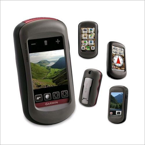
Versatile Mapping and Navigation
The Oregon 550 features a reliable basemap and supports both downloadable and custom maps, ensuring comprehensive navigation capabilities in any terrain. With the ability to save up to 2,000 waypoints and 200 routes, explorers can create, store, and revisit favorite locations with remarkable ease. These advanced mapping features make the device ideal for a wide range of outdoor activities.
Designed for Rugged Environments
Encased in a water-resistant shell rated IPX7, the Oregon 550 is built to withstand immersion in water up to 1 meter for 30 minutes. Its robust design ensures consistent performance in harsh weather conditions, making it an excellent choice for hiking, trekking, or fieldwork in Indias diverse landscapes. The intuitive touchscreen remains effective even under direct sunlight.
Seamless Sharing and Expanded Functions
With wireless sharing, users can exchange waypoints, tracks, routes, or geocaches between compatible Garmin devices. The device also supports paperless geocaching and features an integrated digital camera, offering a holistic outdoor experience. Data transfers and updates are simplified via USB 2.0 and a microSD card slot, ensuring smooth management of maps and files.
FAQs of Garmin Gps Oregon 550:
Q: How do I add new maps to the Garmin Oregon 550?
A: You can add new maps to the Oregon 550 by downloading compatible maps from Garmins website or other providers and transferring them using the included USB 2.0 interface or via a microSD card. The device supports both custom and downloadable maps for enhanced navigation.Q: What is the waterproof rating of the Oregon 550, and what does it mean for outdoor use?
A: The Oregon 550 is rated IPX7, which means it is waterproof up to 1 meter of water for up to 30 minutes. This makes it highly suitable for hiking, boating, and use during rainy weather or near water bodies without worrying about damage.Q: How long does the battery last, and what type of batteries should I use?
A: The Oregon 550 offers up to 16 hours of operation on two AA batteries. For optimal performance, it is recommended to use NiMH or Lithium AA batteries, especially during extended outdoor activities.Q: What process should I follow to share waypoints or routes between devices?
A: To share waypoints, tracks, or routes, ensure both devices are compatible (Oregon or Colorado series), enable wireless sharing in the setup menu, and follow the on-screen prompts to transfer data seamlessly.Q: Is the Oregon 550 suitable for geocaching?
A: Yes, the Oregon 550 fully supports paperless geocaching. You can download geocaches, view descriptions, logs, and hints directly on the device, making it convenient for enthusiasts and beginners alike.Q: What are the GPS accuracy and supported operating systems?
A: The GPS accuracy of the Oregon 550 is less than 10 meters for 95% of the time. The device is compatible with Windows XP or newer and Mac OS X 10.4 or later for map management and data transfers.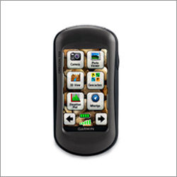
Tell us about your requirement

Price:
Quantity
Select Unit
- 50
- 100
- 200
- 250
- 500
- 1000+
Additional detail
Mobile number
Email

More Products in Garmin Gps Device Category
Garmin Oregon 550t GPS
Price 700 INR / Unit
Minimum Order Quantity : 100 Units
Weight : Approx. 6.8 oz (192.7 g) with batteries
Dimensions : 2.4 x 4.5 x 1.4 (6.1 x 11.4 x 3.6 cm)
Type : Other, Handheld GPS Navigator
Usage : Other, Outdoor navigation, hiking, geocaching, adventure sports

GPS Radio Collars
Weight : 380 g
Dimensions : 28 x 15 x 7 cm
Type : Other, Wireless
Usage : Other, Animal monitoring
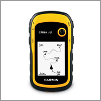
Garmin Etrex 10
Price 14000 INR / Piece
Minimum Order Quantity : 1 Piece
Weight : 10 Kilograms (kg)
Type : GPS Navigator
Usage : Automotive
Garmin 72H GPS Device
Price 5000 INR / Piece
Minimum Order Quantity : 100 Pieces
Weight : 10 Kilograms (kg)
Dimensions : 1 Meter (m)
Type : GPS Navigator
Usage : Automotive
Contact Details
- FLAT NO 306, DOOR NO 3-83/1/PC/306, Panchsheel Complex, NIZAMPET.Hyderabad - 500090, Telangana, India
- Phone : 08045476222
GLOBAL TELE COMMUNICATIONS
GST : 36AHTPR9067J1ZA
- Mr Ganesh Chandu R. (Managing Director)
- Mobile : 08045476222
- Send Inquiry
- Mobile :+919866661290


GLOBAL TELE COMMUNICATIONS
All Rights Reserved.(Terms of Use)
Developed and Managed by Infocom Network Private Limited.
Developed and Managed by Infocom Network Private Limited.
